Monday Weather Blog
After a chilly morning, we will enjoy a nearly perfect weather day! Abundant sunshine, warm temps and low humidity screams for everyone to get outside today! Pollen is high and making some suffer.
Stream Connecticut News for free, 24/7, wherever you are.

Tonight will be fair but we do expect some areas of cloudiness to roll in. Hopefully the Flower Moon will shine through the clouds. Lows will not be as cold as this morning with lows near 50.
Get top local Connecticut stories delivered to you every morning with the News Headlines newsletter.

Tomorrow will remain dry with increasing and thickening clouds and warmer temperatures topping off between 75-80 away from the Sound. Below you can see the rain that will initially stay off to our south and west.

A rising chance of rain develops for tomorrow night and Wednesday. The low pressure system is not very strong so we aren't' expecting too much rain or wind. We do expect the humidity to rise and some instability arrives Thursday. Scattered showers and thunderstorms are possible Wednesday night and Thursday.

All of this is due to a low pressure system over the southeast U.S. that has the chance to provide a few chances through the middle of the week.

On and off showers are expected both Wednesday, Thursday, and potentially lasting into the upcoming weekend.

Right now, signs are pointing to the highest rain totals staying to our south and west. We also know that this system will NOT be a washout in southern New England.

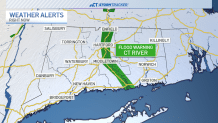
Still, any rainfall will aggravate the already high Connecticut River. There is a flood warning for the river across the entire state until further notice. It's expected to crest by Tuesday.