
Saturday Weather Blog
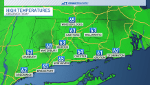
Today temperatures remained in the low to mid 60s across the state with towns in the NW Hills remaining in the upper 50s.
Stream Connecticut News for free, 24/7, wherever you are.
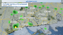
We also saw on and off showers throughout the day. Tonight the risk for a few more showers will be there but the chance of rain will continue to decrease.
Get top local Connecticut stories delivered to you every morning with the News Headlines newsletter.

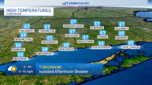
Skies will remain mostly cloudy by the morning as temperatures drop into the 40s and 50s tonight. We could see more breaks in the sky ahead of more sunshine expected through Sunday but a stray shower cannot be ruled out.
Temperatures are expected to be warmer into the mid 60s.
By Memorial Day Monday, high pressure finally pushes the nor'easter out to sea, and we'll see temperatures warmer into the low 70s!

High pressure continues to build allowing us to warm to near 80° by Tuesday.
By the middle of next week, we're monitoring another chance for rain.

Latest model data suggests another area of low pressure that could swing into the Northeast, it will be something to watch as we get closer.
