
Friday Weather Blog
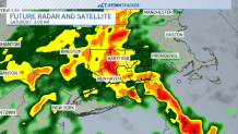
TGIF! An unusually strong storm for late May will move over Connecticut early Saturday. Even though the barometric pressure will be quite low the overall impact should be fairly limited. Heavy rain is expected but not enough to cause flooding and thunderstorms are expected but they won't be severe in nature.
Stream Connecticut News for free, 24/7, wherever you are.
The heaviest rain will fall during the overnight. Downpours are expected in most areas.
Get top local Connecticut stories delivered to you every morning with the News Headlines newsletter.
With some instability in the atmosphere there is a risk for some thunderstorms. Don't be surprised to hear a clap of thunder around or just before daybreak.

The downpours will move out quickly and we'll be left with scattered showers for the day on Saturday. That said, most of the day should be dry and we may even see some breaks of sunshine.

This storm will favor western Connecticut with up to 2" (maybe even a bit more) with closer to an inch elsewhere.

Meteorological summer begins Sunday and even though it will be unseasonably cool warm weather isn't far behind. A large ridge of high pressure will develop pumping in warmer than normal air. Temperatures could make a run at 90F in the Hartford area if the wind direction cooperates.

Most towns will be in the 80s for Tuesday, Wednesday, and Thursday.

Have a great weekend and hopefully we'll turn the page to a pleasant June weatherwise!